Al_'Aqil yatakallamu 'anil syakhsiah
AzZaki yatakallamu 'anil madhiah/qadhiah
A'_'Abqoriyyu yatakallamu 'anil FIKRAH wal ISLAH


29 April 2010
Ijazah Sains Perngurusan Hutan UPM
Alhamdulillah dapat ijzah di UPM pada 16 tahun lalu semasa usia 24 tahun
kini Alhamdulillah dapat uruskan hutan pada usia 40 tahun kini dapat dapat pengalaman menarik di hutan
abah dan mak telah menyokong pengajian ku di UPM dengan usaha dan doa mak abah ...Allhamdulillah saya apat Ijazah
kini Alhamdulillah dapat uruskan hutan pada usia 40 tahun kini dapat dapat pengalaman menarik di hutan
abah dan mak telah menyokong pengajian ku di UPM dengan usaha dan doa mak abah ...Allhamdulillah saya apat Ijazah


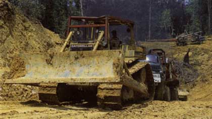
Logging operation impact to environment_destruction to forest stand
THE WELL-DOCUMENTED environmental impacts of logging167 are summarised below. Environmental impact assessments of logging operations in a number of different countries (Papua New Guinea, Solomon Islands and Cameroon, for instance) clearly demonstrate that destructive logging practices using heavy machinery seriously reduce the forest's ability to carry out vital environmental and ecological functions.
Watershed Management and Soil Erosion
Forests provide a buffer to filter water and to hold soil in place. They sustain water and soil resources through recycling nutrients. In watersheds where forests are degraded or destroyed, minimum flows decrease during the dry season, leading to drought, while peak floods and soil erosion increase during
Tributary meets Melinau River, upper reaches of Baram river. Tributary water (left of picture), from preserved, non-logged and non-eroded watershed. Water from main river is cloudy with sediment from logging operations.
Flooding along the Baram River in Sarawak has increased significantly since logging began, the major floods occurring in 1979 and 1981.168 Massive floods, directly linked to excessive logging, have caused hundreds of deaths in the Philippines169 and Thailand.170
Much of the current logging carried out in Sarawak and other places is on steep lands dominated by surface materials that are highly susceptible to erosion when disturbed.171 Data collected by the Malaysian Department of Environment in 90 long-term sampling site locations within 21 river basins has detected incredibly high suspended sediment loads in most rivers and tributaries. This mainly originates from upstream soil erosion caused by the indiscriminate construction of logging roads and camps, skid trails and logging itself.172 Dr Saulei of the University of Papua New Guinea also blames the logging industry for 'accelerating erosion, weathering and humus decomposition, and leading to widespread formation of soils with low nutrient and absorptive capacities'
A skid track with severe erosion. More than a metre of topsoil has been lost and the bedrock exposed along many metres of this skid track on Isabel Island, Solomon Islands (see Kumpulan Emas, page 44).
The scale of inputs of mobilised sediment is clearly seen in this photograph where many tonnes of material are being made transportable from machinery-mediated topsoil disturbance and the loss of vegetative cover and litter layers.
Local Climate Regulation
Beside the implications of large-scale logging for global warming, drastic changes in precipitation are direct and immediate when the forest cover is removed.174 Changes in transpiration result in a greater intensity of tropical rainfall, enhancing both run-off and erosion, even if the total amount of rainfall remains unchanged. Forest loss can also make rainfall more erratic, thus lengthening dry periods.175
Forest Fires
Most of the destructive forest fires that have recently raged out of control across the world, from the Amazon to Indonesia, are widely acknowledged to have been either started by and/or exacerbated by logging and agricultural development companies, such as the oil palm industry. One of the most detailed studies on the effects of fires in Kalimantan, Indonesia, concludes that the considerable decrease in foliage and related changes in the stand structure, increase of albedo, and horizontal and vertical air movements caused by fires, may produce significant and lasting effects on the regional climate.176
Impacts on the Marine Environment
Unsustainable logging mobilises debris that not only finds its way into the streams and rivers but also to the marine environment, where it damages mangroves and coral reefs, habitats crucial for aquatic life. In the Solomon Islands, the unique Marovo Lagoon, a proposed World Heritage Site, is threatened by the ecologically-destructive logging operations occurring in the surrounding forests. In Papua New Guinea, coral reefs have been destroyed to construct log ponds.
Loss of Biodiversity
Logging often destroys natural habitats, resulting in the loss of biodiversity and sometimes leading to the local, and possibly global, extinction of species. Although estimates of the rates of loss vary, few deny the reality of the current losses of both flora and fauna.177
According to a joint report by the Worldwide Fund for Nature and the Sarawak Forest Department, "Logging causes immediate forest disturbances, long-term habitat changes (e.g. damage to food trees and salt-licks), increased hunting by timber company workers and availability of logging roads as hunting routes. The destruction of wildlife from habitat loss must be recognised to be on an enormous scale".178 In Central Africa, the opening-up of the forest by logging facilitates the illegal hunting of wildlife, including protected species such as primates, and is leading to a decline in wildlife populations.179 Deterioration in water quality has caused a decline in fish stocks and has affected aquatic biological diversity because indigenous animals and plant life are highly vulnerable to oxygen depletion, suspended particulate matter and a lack of light.180
Even so called selective logging severely affects the complex and rich biodiversity of forests through excessive damage to residual stands, destruction of other plant and tree species and the creaming-off of species which are the most valuable for timber. An FAO study in Malaysia has shown that as much as 50% of the standing forest may be damaged and the surface soil destroyed when up to 30% of the ground surface is exposed. During silvicultural treatment in logging operations in Sarawak, so-called uneconomic forest species are deliberately poisoned. This reduces the complexity and species diversity of the tropical forests to only 10% of the original condition, resulting in the systematic elimination of tree genetic resources and contamination of the environment.181 According to the IUCN the most frequently recorded of all threats to globally endangered tree species is 'felling'
Destructive logging practices using heavy machinery seriously reduce the forest's ability to carry out vital environmental and ecological functions.
28 April 2010
pulp and paper_the star
Paper consumption is set to increase
The Star, 19 January 2009
KUALA LUMPUR: Paper consumption is set to increase over the years, and the Government should make it more attractive for local industrialists to set up more paper mills here in collaboration with foreign investors.
“More than half of what is used now is imported,” Malaysia Paper Merchants’ Association (MaPMA) secretary Manmohan Singh Kwatra said at its 20th anniversary dinner last night which was graced by Deputy Finance Minister Datuk Kong Cho Ha.
“About 150,000 tonnes is produced locally at the Sabah Forest Industries (SFI) in Sipitang, Sabah, Malaysia’s first integrated pulp and paper mill.”
Malaysia consumes about 380,000 tonnes of printing and writing paper annually, of which about 230,000 tonnes are imported, including from Indonesia and Thailand.
“With attractive incentives, our mill partners from the neighbouring countries will be more attracted to add on to, or shift, their operations to Malaysia, while SFI will certainly consider expansion plans to meet the present shortfall and the annual growing demand,” Manmohan added.
SFI’s production, he said, was set to increase to 180,000 tonnes a year within the next two years.
Kong meanwhile said the Government would always hold a dialogue with the industry prior to formulating a policy or law.
He encouraged the setting up of more paper mills in the country given that demand for paper would continue to rise.
“I encourage paper merchants to come together and invest in the industry so that we do not have to depend so much on imported paper, as imports can affect pricing,” he added.
He said the fluctuating oil prices had affected all industries, including the paper industry, making budgeting and purchasing difficult.
21 April 2010
bahaya khawarij_penulisan Ust Emran Ahmad
Mazhab Khawarij adalah merupakan mazhab Aqidah yang paling lama dan terawal muncul selepas Ahlul Sunnah Wal Jamaah. Bahkan kemunculan mazhab Khawarij adalah lebih dahulu daripada Syi’ah.
Kalimah Khawarij di dalam bahasa Arab : خوارج bermaksud “Mereka yang Keluar” dan hal ini daripada sudut Istilah merujuk kepada kefahaman golongan yang keluar daripada ketaatan kepada Khalifah Ali bin Abi Tolib radiallahuanhu serta menolaknya.
Ajaran Khawarij ini sebenarnya telah muncul semenjak di zaman rasulullah lagi apabila mereka ini dikenali sebagai kaum pemberontak dan penentang yang menganggap hanya mereka sahaja yang benar sedangkan orang lain semuanya salah.
Hal ini berlaku berdasarkan riwayat Abu Said Al-Khudri radiallahuanhu yang menceritakan bahawa ada seorang lelaki yang berkata kepada rasulullah sewaktu baginda membahagikan barangan kepada para sahabat supaya baginda berlaku adil. Maka ditegur oleh baginda dengan berkata : “Celakalah kamu bukankah aku ini orang yang paling bertaqwa kepada Allah ?” Maka Khalid Al-Walid ingin membunuh lelaki itu tetapi ditahan oleh Rasulullah dan baginda kemudian mengatakan bahawa daripada keturunan lelaki ini akan lahir golongan yang akan membaca Al-Quran tetapi bacaan itu tidak pun melewati kerongkong mereka dan agama ini akan terlepas daripada diri mereka seperti terlepasnya anak panah dari busurnya.
Menurut Kitab-kitab Firaq (perpecahan umat) awal kemunculan Khawarij secara rasmi ialah semasa zaman Amirul Mukminin Ali bin Abi Tolib radiallahuanhu sewaktu terjadinya Majlis Tahkim bersama dengan Muawiyah radiallahuanhu. Mereka berkumpul disuatu tempat yang disebut Harurah (sebuah kawasan di daerah Kufah) dan membantah perlaksanaan Majlis tersebut kerana menganggap ianya membelakangi Kitab Allah dan hukum Allah swt.
Namun hakikatnya itu bukanlah punca sebenar mereka keluar daripada pasukan Ali bin Abi Tolib radiallahuanhu.
Mereka juga sebelum kemunculan secara rasmi telah bertanggungjawab kepada beberapa siri fitnah dan kejahatan seperti pembunuhan Khalifah Utsman bin Affan radiallahuanhu. Setelah Utsman dibunuh, mereka kemudian bersembunyi ke dalam pasukan dan penyokong Ali bin Abi Tolib untuk mengelakkan diri mereka daripada diburu dan dibunuh balas oleh Muawiyah radiallahuanhu yang memiliki hubungan kekeluargaan dengan Khalifah Utsman bin Affan.
Pembunuh Utsman adalah tidak diketahui kerana jumlahnya ramai dan apabila Ali bertanya kepada golongan Khawarij ini siapakah yang membunuh Utsman maka ribuan manusia daripada penyokong Khawarij ini mengaku telah membunuh Utsman lalu hal itu menyebabkan Khalifah Ali bin Abi Tolib radiallahuanhu menangguhkan usaha untuk melakukan Qisos ke atas Utsman sehingga menyebabkan ketidak puasan hati di sisi Muawiyah dan juga ramai sahabat yang lain.
Akhirnya terjadilah perang siffin kerana perbezaan pendapat dan juga kerana masing-masing pasukan diapi-apikan oleh golongan munafiqin (seperti kaum Khawarij dan Abdullah bin Saba’ daripada Syiah). Kemudian masing-masing pihak mengirim utusan untuk berunding maka terjadilah perdamaian antara kedua belah pihak dan Majlis Tahkim.
Melihat hal ini orang-orang Khawarij menjadi bimbang bahawa dengan perdamaian di antara Ali dan para sahabat seperti Muawiyah akan menyebabkan mereka ditangkap dan diburu kerana telah membunuh Utsman bin Affan radiallahuanhu maka akhirnya mereka pun melarikan diri dan keluar daripada pasukan Ali bin Abi Tolib dan menubuhkan pasukan mereka sendiri untuk menyelamatkan diri.
Mereka juga kemudian membuat perancangan untuk membunuh para pemimpin Islam seperti Khalifah Ali bin Abi Tolib dan Muawiyah bin Abi Sufyan dan lain-lain sahabat radiallahuanhum tetapi hanya Ali yang berjaya di bunuh sewaktu solat subuh di masjid.
Khawarij menafsirkan Kitab Al-Quran secara zahir.
Mereka menolak tafsiran Al-Quran oleh para sahabat dan memahami Islam secara hukum zahir dan mengambil lafaz-lafaz Al-Quran secara zahir ayat. Hal ini menyebabkan mereka tersesat dan ditambah pula oleh sikap ta’asub mereka kepada diri mereka dan ibadah mereka yang tersangat banyak melebihi ibadah para sahabat menyebabkan mereka memperendahkan para sahabat rasulullah dan tidak mengambil hadis yang bertentangan dengan kefahaman dan tafsiran mereka.
Golongan Khawarij kemudian berkumpul serta berpusat di Nahrawan dan melantik Imam dan ketua perang mereka sendiri serta menubuhkan pasukan ketenteraan dan jamaah mereka dengan memiliki Imam solat, tukang azan dan mendirikan insititusi agama yang diharapkan dapat mengatasi ajaran Islam yang dikuasai oleh para sahabat rasulullah salallahualaihiwasalam.
Mereka mengkafirkan sejumlah besar para sahabat, khalifah-khalifah Islam dan umat Islam yang melakukan dosa besar serta maksiat pada pandangan mereka. Iman di sisi mereka ialah tetap dan tidak boleh berkurang dan jika berkurang pada seseorang kerana maksiat maka orang itu di sisi mereka telah menjadi kafir. Dakyah mereka sangat merbahaya sehingga mengakibatkan ramai para sahabat telah ditangkap dan dibunuh kerana pada anggapan mereka para sahabat rasulullah telah menjadi murtad disebabkan mereka tidak sefahaman dengan kepercayaan Khawarij.
Pokok seruan Khawarij ialah seperti berikut :
1) Kaum muslimin yang melakukan dosa besar adalah kafir
2) Al-Quran ditafsirkan menurut lafaz zahir
3) As-Sunnah tidak diterima sebagai hujah kerana nabi boleh tersalah dan tersilap dan para sahabat baginda tiada kelebihan bahkan kaum yang sesat
4) Pemimpin atau Imam boleh diangkat daripada sesiapa sahaja tidak semestinya daripada kaum Quraisy sebaliknya boleh jadi daripada hamba dan bahkan daripada kaum wanita.
5) Para sahabat yang terlibat di dalam perang Jamal, menerima majlis Tahkim ialah kafir.
Tokoh-tokoh utama Khawarij ialah Abdullah bin Wahhab ar-Rasyidi , Urwah bin Hudair , Mustarid bin Sa'ad , Hausarah al-Asadi , Quraib bin Maruah , Nafi' bin al-Azraq , Abdullah bin Basyir , Najdah bin Amir al-Hanafi yang mana setiap daripada mereka ini kemudian mempunyai pengikut dan menghasilkan cabang daripada ajaran Khawarij yang tambah menyesatkan dan menyeleweng daripada Islam yang lurus.
Sehingga kini sebilangan kecil Mazhab Kahwarij masih wujud di dunia Islam seperti kelompok Ibadi di Negara Oman, Zanzibar, dan Maghrib walaubagaimanapun mereka menolak untuk dikenali sebagai Khawarij.
Kesimpulannya Imam Al-Shahrastani menyatakan bahawa sesiapa yang keluar memberontak daripada Imam yang sah dilantik oleh jamaah umat Islam ialah Khawarij tidak kira apakah di zaman sahabat, tabien atau selepas mereka selama wujud Imam-imam yang sah. (Lihat : Kitab Al-Milal Wa Al-Nihal, Jilid 1, ms. 101)
Golongan salaf pula menjelaskan bahawa Khawarij ini ialah golongan yang beramal di dalam Islam menurut pendapat mereka sendiri dan mengambil ayat-ayat zahir di dalam Al-Quran tanpa merujuk kefahaman salaf soleh dan penafsiran rasulullah serta menolak hadis rasulullah dan tafsiran agama oleh para sahabat baginda.
Semoga Allah menjauhkan kita daripada mereka.
http://ustaz.blogspot.com/
perisai untuk anak_penulisan ustaz Emran Ahmad
Berikut ialah nasihat dan pedoman untuk memagari rumah dan anak-anak daripada gangguan syaitan seperti yang diajarkan oleh Al-Quran dan As-sunnah.
1. Membaca surah Al-baqarah di dalam rumah
Rasullullah bersabda:"Janganlah jadikan rumah kamu sebagai kuburan. Sesungguhnya rumah yang dibacakan padanya surah Al-Baqarah tidak akan dimasuki syaitan." (Hadis riwayat Muslim)
2. Membaca Bismillah sebelum masuk dan semasa keluar daripada rumah
3. Membaca ayat kursi kepada anak-anak sebelum tidur
{ اللَّهُ لا إِلَهَ إِلاَّ هُوَ الْحَيُّ الْقَيُّومُ لا تَأْخُذُهُ سِنَةٌ وَلا نَوْمٌ لَهُ مَا فِي السَّمَوَاتِ وَمَا فِي الأَرْضِ مَنْ ذَا الَّذِي يَشْفَعُ عِنْدَهُ إِلاَّ بِإِذْنِهِ يَعْلَمُ مَا بَيْنَ أَيْدِيهِمْ وَمَا خَلْفَهُمْ وَلا يُحِيطُونَ بِشَيْءٍ مِنْ عِلْمِهِ إِلاَّ بِمَا شَاءَ وَسِعَ كُرْسِيُّهُ السَّمَوَاتِ وَالأَرْضَ وَلا يَئُودُهُ حِفْظُهُمَا وَهُوَ الْعَلِيُّ الْعَظِيمُ }
4. Membaca doa berikut kepada anak, sambil tangan mengusap kepalanya :
اعذك بكلمات الله التامة من كل شيطان وشره
Maksudnya : “Aku mohon perlindungan untuk kamu dengan kalimah-kalimah Allah yang sempurna dan semua perbuatan syaitan dan kejahatannya.”
5. Membaca Surah Al-Ikhlas, Al-Falaq dan An-Nas kemudian sapu seluruh badan sebelum tidur
Satu hadith daripada Aishah RA, mengatakan, bahawa apabila Rasulullah صلى الله عليه وسلم berbaring di perbaringan baginda pada malam hari, baginda menyatukan kedua telapak tangan baginda lalu baginda meniup keduanya dan membacakan surah Al-Ikhlas, Al-Falaq dan An-Nas. Kemudian baginda mengusap tubuh baginda yang mampu diusap dengan kedua tangannya. Baginda mulai dari kepala, wajah, dan bahagian muka tubuhnya. Baginda melakukan hal itu tiga kali.“ (Hadith sahih Bukhari, riwayat Aishah RA)
6. Bersihkan hidung jika terjaga tengah malam
Abu Hurairah RA berkata, bahawa Rasulullah صلى الله عليه وسلم bersabda, maksudnya: “Apabila salah seorang di antara kamu terbangun dari mimpinya, hendaklah dia melakukan membersihkan hidungnya tiga kali, kerana syaitan bermalam pada hidungnya.” (Hadith Riwayat Bukhari dan Muslim)
7. Disebut dalam Sahih Muslim, diriwayatkan daripada Abu Hurairah r.a katanya: Rasulullah صلى الله عليه وسلم bersabda (maksudnya): Sesiapa yang membaca 100 kali :
لا إله إلا الله وحده لا شريك له له الملك وله الحمد وهو على كل شيء قدير
dibuat untuknya benteng sebagai pelindung dari syaitan pada hari tersebut hingga ke petang.
p/s :
Demi menjadikan amalan di atas berkesan maka terlebih dahulu orang yang mengamalkannya haruslah beriman dan melaksanakan perintah Al-Quran itu sendiri serta membersihkan diri dan ahli keluarganya daripada syirik dan maksiat kepada Allah SWT kerana tiadalah makbul doa melainkan dari jiwa yang suci daripada syirik dan derhaka kepada Allah SWT.
http://ustaz.blogspot.com/
20 April 2010

18 April 2010

17 April 2010
.JPG)
15 April 2010


14 April 2010
forest protection and management
Guidelines for Protected Area Management Categories
Basic Concepts
The starting point must be a definition of a protected area. The definition adopted is derived from that of the workshop on Categories held at the IVth World Congress on National Parks and Protected Areas:
An area of land and/or sea especially dedicated to the protection and maintenance of biological diversity, and of natural and associated cultural resources, and managed through legal or other effective means.
This definition embraces the 'universe' of protected areas. All categories must fall within this definition. But although all protected areas meet the general purposes contained in this definition, in practice the precise purposes for which protected areas are managed differ greatly. The following are the main purposes of management:
Scientific research
Wilderness protection
Preservation of species and genetic diversity
Maintenance of environmental services
Protection of specific natural and cultural features
Tourism and recreation
Education
Sustainable use of resources from natural ecosystems
Maintenance of cultural and traditional attributes
Having regard to the different mix and priorities accorded to these main management objectives, the following emerge clearly as distinct categories of protected areas:
Areas managed mainly for:
I Strict protection (i.e. Strict Nature Reserve / Wilderness Area)
II Ecosystem conservation and recreation (i.e. National Park)
III Conservation of natural features (i.e. Natural Monument)
IV Conservation through active management (i.e. Habitat/Species Management Area)
V Landscape/seascape conservation and recreation (i.e. Protected Landscape/Seascape)
VI Sustainable use of natural ecosystems (i.e. Managed Resource Protected Area)
However, most protected areas also serve a range of secondary management objectives.
The relationship between management objectives and the categories is illustrated in matrix form in the table below. It is developed further in Part II, where each category is described, and through a range of examples presented in Part III.
This analysis is the foundation upon which the international system for categorising protected areas was developed by IUCN and which is presented in these guidelines. There are several important features to note:
the basis of categorisation is by primary management objective;
assignment to a category is not a commentary on management effectiveness;
the categories system is international;
Table Matrix of management objectives and IUCN protected area management categories
MANAGEMENT OBJECTIVE
Ia
Ib
II
III
IV
V
VI
Scientific research
1
3
2
2
2
2
3
Wilderness protection
2
1
2
3
3
-
2
Preservation of species and genetic diversity
1
2
1
1
1
2
1
Maintenance of environmental services
2
1
1
-
1
2
1
Protection of specific natural/cultural features
-
-
2
1
3
1
3
Tourism and recreation
-
2
1
1
3
1
3
Education
-
-
2
2
2
2
3
Sustainable use of resources from natural ecosystems
-
3
3
-
2
2
1
Maintenance of cultural/traditional attributes
-
-
-
-
-
1
2
Key:
1 Primary objective
2 Secondary objective
3 Potentially applicable objective
- Not applicable
national names for protected areas may vary;
a new category is introduced;
all categories are important;
but they imply a gradation of human intervention.
These points are discussed in turn.
The Basis of Categorisation is by Primary Management Objective
In the first instance, categories should be assigned on the basis of the primary management objective as contained in the legal definitions on which it was established; site management objectives are of supplementary value. This approach ensures a solid basis to the system, and is more practical. In assigning an area to a category, therefore, national legislation (or similar effective means, such as customary agreements or the declared objectives of a non-governmental organization) will need to be examined to identify the primary objective for which the area is to be managed.
Assignment to a Category is not a Commentary on Management Effectiveness
In interpreting the 1978 system, some have tended to confuse management effectiveness with management objectives. For example, some areas which were set up under law with objectives appropriate to Category II National Parks have been reassigned to Category V Protected Landscapes because they have not been protected effectively against human encroachment. This is to confuse two separate judgements: what an area is intended to be; and how it is run. IUCN is developing a separate system for monitoring and recording management effectiveness; when complete, this will be promoted alongside the categories system, and information on management effectiveness will also be collected and recorded at the international level.
The Categories System is International
The system of categories has been developed, inter alia, to provide a basis for international comparison. Moreover, it is intended for use in all countries. Therefore the guidance is inevitably fairly general and will need to be interpreted with flexibility at national and regional levels. It also follows from the international nature of the system, and from the need for consistent application of the categories, that the final responsibility for determining categories should be taken at the international level. This could be IUCN, as advised by its CNPPA and/or the World Conservation Monitoring Centre (e.g., in the compilation of the UN List) in close collaboration with IUCN.
National Names for Protected Areas may Vary
In a perfect world, IUCN's system of categories would have been in place first, and national systems would have followed on, using standard terminology. In practice, of course, different countries have set up national systems using widely varying terminology. To take one example, 'national parks' mean quite different things in different countries. Many nationally-designated 'national parks' do not strictly meet the criteria set by Category II under the 1978 system. In the United Kingdom, for example, 'National Parks' contain human settlement and extensive resource use, and are properly assigned to Category V. In South America, a recent IUCN study found that some 84 percent of national parks have significant resident human populations; some of these might be more appropriately placed in another category.
Since so much confusion has been caused by this in the past, Part II of these guidelines identifies the categories by their main objectives of management as well as their specific titles. Reference is also made to the titles used in the 1978 system because some, at least, have become widely known.
At the national level, of course, a variety of titles will continue to be used. Because of this, it is inevitable that the same title may mean different things in different countries; and different titles in different countries may be used to describe the same category of protected area. This is all the more reason for emphasising an international system of categorisation identified by management objectives in a system which does not depend on titles.
A New Category is Introduced
The Recommendation adopted at Caracas invited IUCN to consider further the views of some experts that a category is needed to cover predominantly natural areas which "are managed to protect their biodiversity in such a way as to provide a sustainable flow of products and services for the community". Consideration of this request has led to the inclusion in these guidelines of a category where the principal purpose of management is the sustainable use of natural ecosystems. The key point is that the area must be managed so that the long-term protection and maintenance of its biodiversity is assured. In particular, four considerations must be met:
the area must be able to fit within the overall definition of a protected area (see above),
at least two-thirds of the area should be, and is planned to remain in its natural state,
large commercial plantations are not to be included, and
a management authority must be in place.
Only if all these requirements are satisfied, can areas qualify for inclusion in this category.
All Categories are Important
The number assigned to a category does not reflect its importance: all categories are needed for conservation and sustainable development. Therefore IUCN encourages countries to develop a system of protected areas that meets its own natural and cultural heritage objectives and then apply any or all the appropriate categories. Since each category fills a particular 'niche' in management terms, all countries should consider the appropriateness of the full range of management categories to their needs.
...But they imply a Gradation of Human Intervention
However, it is inherent in the system that the categories represent varying degrees of human intervention. It is true that research has shown that the extent of past human modification of ecosystems has in fact been more pervasive than was previously supposed; and that no part of the globe can escape the effects of long-distance pollution and human-induced climate change. In that sense, no area on earth can be regarded as truly 'natural'. The term is therefore used here as it is defined in Caring for the Earth:
Ecosystems where since the industrial revolution (1750) human impact (a) has been no greater than that of any other native species, and (b) has not affected the ecosystem's structure. Climate change is excluded from this definition.
Under this definition, categories I to III are mainly concerned with the protection of natural areas where direct human intervention and modification of the environment has been limited; in categories IV, V and VI significantly greater intervention and modification will be found.
protected area management
INTRODUCTION
At the IV World Congress on National Parks and Protected Areas, meeting in Caracas, Venezuela in February 1992, participants concluded that more and better managed protected areas were urgently required. Participants emphasised that protected areas are about meeting people's needs: that protected areas should not be islands in a sea of development but must be part of every country's strategy for sustainable management and the wise use of its natural resources, and must be set in a regional planning context.
The Caracas Congress also declared its belief in the importance of the full range of protected areas, from those that protect the world's great natural areas to those that contain modified landscapes of outstanding scenic and cultural importance. Within this broad spectrum of uses, many names have been applied to protected areas; Australia alone uses some 45 names and the US National Park Service has 18 different types of areas under its mandate. Globally, over 140 names have been applied to protected areas of various types. Bringing some order to this diversity is clearly a very useful step.
The purpose of these guidelines, therefore, is to establish greater understanding among all concerned about the different categories of protected areas. A central principle upon which the guidelines are based is that categories should be defined by the objectives of management, not by the title of the area nor by the effectiveness of management in meeting those objectives. The matter of management effectiveness certainly needs to be addressed, but it is not seen as an issue of categorisation.
The guidelines build on work done by IUCN in this field over the past of a quarter century. In particular, they draw on the efforts of a task force established in 1984. They reflect the outcome of a wide-ranging debate over the past few years among protected area managers from around the world, including discussion and review at a workshop in Caracas. The outcome of this workshop was that the Congress adopted a recommendation urging that the IUCN Commission on National Parks and Protected Areas and the IUCN Council endorse a system of categories for protected areas according to management objectives and that the system be commended to governments and explained through guidelines. The present publication is designed to give effect to this particular recommendation.
It is hoped that these guidelines will be used widely by those planning to set up new protected areas, and by those reviewing existing ones. They are designed to form a useful basis for preparing national protected areas systems plans. It is to be emphasized that these categories must in no way be considered as a 'driving' mechanism for governments or organizations in deciding the purposes of potential protected areas. Protected areas should be established to meet objectives consistent with national, local or private goals and needs (or a mixture of these) and only then be labelled with an IUCN category according to the management objectives developed herein. These categories have been developed to facilitate communication and information, not to drive the system.
The guidelines do not stand alone, of course. Much other advice on the management of protected areas has been published by IUCN in recent years, and more is to come as the fruits of the work at Caracas emerge in print. But these guidelines have a special significance as they are intended for everyone professionally involved in protected areas, providing a common language by which managers, planners, researchers, politicians, and citizen groups in all countries can exchange information and views.
P.H.C. (Bing) Lucas
Chair, IUCN Commission on National Parks and Protected areas
protected area management
Guidelines for Protected Area Management Categories
Background
Through its Commission on National Parks and Protected Areas (CNPPA), IUCN has given international guidance on the categorisation of protected areas for nearly a quarter of a century. The purposes of this advice have been:
to alert governments to the importance of protected areas;
to encourage governments to develop systems of protected areas with management aims tailored to national and local circumstances;
to reduce the confusion which has arisen from the adoption of many different terms to describe different kinds of protected areas;
to provide international standards to help global and regional accounting and comparisons between countries;
to provide a framework for the collection, handling and dissemination of data about protected areas; and
generally to improve communication and understanding between all those engaged in conservation.
As a first step, the General Assembly of IUCN defined the term 'national park' in 1969. Much pioneer work was done by Dr Ray Dasmann, from which emerged a preliminary categories system published by IUCN in 1973. In 1978, IUCN published the CNPPA report on Categories, Objectives and Criteria for Protected Areas, which was prepared by the CNPPA Committee on Criteria and Nomenclature chaired by Dr Kenton Miller. This proposed these ten categories:
I Scientific Reserve/Strict Nature Reserve
II National Park
III Natural Monument/Natural Landmark
IV Nature Conservation Reserve/Managed Nature Reserve/Wildlife Sanctuary
V Protected Landscape
VI Resource Reserve
VII Natural Biotic Area/Anthropological Reserve
VIII Multiple Use Management Area/Managed Resource Area
IX Biosphere Reserve
X World Heritage Site (natural)
This system of categories has been widely used. It has been incorporated in some national legislation, used in dialogue between the world's protected area managers, and has formed the organisational structure of the UN List of National Parks and Protected Areas (which in recent editions has covered Categories I-V).
Nonetheless, experience has shown that the 1978 categories system is in need of review and updating. The differences between certain categories are not always clear, and the treatment of marine conservation needs strengthening. Categories IX and X are not discrete management categories but international designations generally overlain on other categories. Some of the criteria have been found to be in need of a rather more flexible interpretation to meet the varying conditions around the world. Finally, the language used to describe some of the concepts underlying the categorisation needs updating, reflecting new understandings of the natural environment, and of human interactions with it, which have emerged over recent years.
In 1984, therefore, CNPPA set up a task force to review the categories system and revise it as necessary. This had to take account of several General Assembly decisions dealing with the interests of indigenous peoples, wilderness areas and protected landscapes and seascapes. The report of the task force, which was led by the then Chair of the CNPPA, Mr Harold Eidsvik, was presented to a CNPPA meeting at the time of the IUCN General Assembly in Perth, Australia, in November 1990. It proposed that the first five categories of the 1978 system should form the basis of an up-dated system; it also proposed the abandonment of categories VI-X.
The report was generally well received. It was referred to a wider review at the Fourth World Congress on National Parks and Protected Areas, at Caracas, Venezuela, February 1992. The Congress workshop to which the topic was assigned also had before it an analysis by IUCN consultant, Mr John Foster. Members of the workshop reviewed this material and recommended the early production of guidelines to replace those adopted in 1978. This was formally affirmed in Recommendation 17 of the Congress. Revised guidelines were then prepared and reviewed by the CNPPA Steering Committee and the IUCN Council in accordance with Recommendation 17. The result is these present guidelines, which incorporate general advice on protected area management categories (Part I), consider each of the categories in turn (Part II), and include a number of examples from around the world showing the application of the different categories (Part III).
These present guidelines, therefore, represent the culmination of an extensive process involving a wide-ranging review within the protected area constituency over a number of years. The opinions of those involved have been many. Some have recommended radical changes from the 1978 guidance; others no change whatsoever. Some have urged that there be regional versions of the guidelines; others that the categories be rigidly adhered to everywhere.
The conclusion is guidelines which:
adhere to the principles set forth in 1978 and reaffirmed in the task force report in 1990;
update the 1978 guidelines to reflect the experience gained over the years in operating the categories system;
retain the first five categories, while simplifying the terminology and layout;
add a new category;
recognise that the system must be sufficiently flexible to accommodate the complexities of the real world;
illustrate each of the six categories with a number of brief case studies to show how the categories are being applied around the world; and
provide a tool for management, not a restrictive prescription.
issues of the protected forest management in Peru, Australia etc
Guidelines for Protected Area Management Categories
TAMSHIYACU-TAHUAYO COMMUNAL RESERVE, Peru
National designation Tamshiyacu-Tahuayo was notified as a 322,500ha communal reserve in 1990 under the Regulation of the Conservation of Flora and Wildlife, 1977 relating to the Forest and Wildlife Law, 1975.
Legal basis for management The Forest and Wildlife Law and its subsequent Regulation of the Conservation of Flora and Wildlife provide for the conservation and exploitation of wild resources (usually fauna) within communal reserves for the benefit of local communities. Beneficiaries are responsible for the management of the reserve according to the regulations issued by the local forest administration. No exploitation, other than that carried out for the benefit of local communities, is allowed. Permitted activities typically include sustainable hunting and harvesting of non-timber forest products, such as seeds, fruits, bark, latex, leaves and medicinal plants.
In situ management The reserve is zoned into a totally protected core and a surrounding resource-use area, in which subsistence agriculture and sustainable exploitation of wild resources are practised. Local inhabitants hunt deer, tapir and peccary as important sources of protein. Palm fruits are harvested without damaging the parent trees by tree climbing and other appropriate techniques. Agroforestry is also practised using small, multi-species plots. Fishing takes place in the major rivers and ox-bow lakes, but it is regulated by the Ribereño communities: the use of nets and lances is prohibited during low water, and commercial fisheries are banned.
Geography The reserve lies in north-east Peru between the Tamshiyacu, Tahuayo and Yavari Miri rivers in an area of non-flooded terra firme forest.
Nature conservation values Tamshiyacu-Tahuayo supports a rich flora and fauna, including 13 primate species, two of which are not found within any other protected area. Its terra firme forest complements the flooded forest of the nearby Pacaya-Samiria National Reserve.
Cultural and social values There are no residents within the reserve, but some 4,300 people live on its borders, and a further 2,000 people live close enough to benefit from the exploitation of its resources. The inhabitants are semi-indigenous, non-tribal people known as ribereños.
Reasons for classification as VI (Managed Resource Protected Area) Tamshiyacu-Tahuayo is a large, predominantly natural forest that is communally managed to conserve its biological diversity, while providing its semi-indigenous inhabitants with a range of natural products for local use or consumption. Sustainable use of wild resources is restricted to an area of subsistence use that surrounds a strictly protected core.
TONDA WILDLIFE MANAGEMENT AREA, Papua New Guinea
National designation Tonda was declared a wildlife management area in 1975 under the Fauna (Protection and Control) Act, 1966. The entire 590,000ha of land is held under customary tenure.
Legal basis of management Although concerned primarily with the protection of threatened species, the Fauna (Protection and Control) Act provides for the establishment of wildlife management areas, thereby involving customary land owners in the control of wildlife exploitation.
In situ management Under the enabling legislation a Wildlife Management Committee has been established to advise on the provision of rules for the area. Gazetted in 1976, the rules permit customary landowners to hunt freely. Tourists are charged a nominal entry fee and may hunt only deer, duck and two species of barramundi in limited quantities. According to the rules, hunting is prohibited in the region between the Bensbach and Morehead rivers. Other restrictions include the use of vehicles or boats for hunting.
Geography Tonda lies in southern Papua New Guinea on the southern margin of the Oriomo Plain, a relict alluvial floodplain rising to 45m at Morehead Ridge on the northern boundary. Three major river systems traverse the area; impeded drainage causes widespread seasonal flooding.
Nature conservation values The vegetation is similar in physiognomy and species composition to that of northern Australia, in contrast to most of lowland New Guinea. This reflects the strongly seasonal climate and the geological history of former land connections with the Australian continent. The presence of a relict Australian flora and fauna, mixed with species characteristic of or endemic to New Guinea, is important for conservation.
Cultural and social values There are about 1,200 inhabitants distributed among 16 villages. Ten of these villages occupy lands lying completely within the management area and six occupy lands within and beyond its boundaries. The population is mobile and abandoned villages are evident. Hunting, fishing and egg-collecting play an important part in subsistence and cash economies. Shifting cultivation occurs in forest areas, operating on a fallow period of 15-30 years.
Reasons for classification as VI (Managed Resource Protected Area) Tonda was established as a wildlife management area at the request of the customary land-owners for the conservation and controlled utilisation of wildlife and other natural resources. Human population density is very low and much of the area remains wild and untouched.
BUSTARD FISH HABITAT RESERVE, Australia
Declared in 1983 under the Queensland Fisheries Act 1976, the 4550ha reserve protects fish habitats below the higher high water spring tide level. It comprises the least disturbed marine environment in the locality, and supports an unusually high diversity of fish species. Management is the responsibility of the Queensland Department of Primary Industries. The principal management objective is to protect the habitat, while providing for the continued productivity of fisheries. Prohibited activities include damage to the habitat, removal or disturbance to fish and other taxa except by approved methods, and dumping or dredging. However, fishing by approved methods, access, and boating are permitted.
KIUNGA MARINE NATIONAL RESERVE, Kenya
Kiunga Marine National Reserve protects 25,000ha of relatively pristine tropical coastal habitats, managed sustainably for the benefit of the local community. It comprises a narrow strip of mainland, about fifty small offshore islands and the surrounding waters. The offshore islands support large nesting colonies of seabirds. There has been relatively little human interference in the area, other than limited exploitation of local wildlife. As a marine national reserve designated under the Wildlife Conservation and Management Act, 1976, Kiunga is managed for the preservation and sustainable use of its natural resources. Artisanal fishing represents the main local use of natural resources. Tourism and non-destructive activities, such as swimming and sailing, are permitted. Fishing by specified traditional means is allowed, but not by use of poison, spearguns or dynamite. Collection of shells and corals is also prohibited. The passage and anchorage of boats, diving, and access by non-locals are controlled by permits.
guide line for managing the protected forest as the home for fauna
Guidelines for Protected Area Management Categories
CATEGORY IV
Habitat/Species Management Area: protected area managed mainly for conservation through management intervention
Definition
Area of land and/or sea subject to active intervention for management purposes so as to ensure the maintenance of habitats and/or to meet the requirements of specific species.
Objectives of Management
to secure and maintain the habitat conditions necessary to protect significant species, groups of species, biotic communities or physical features of the environment where these require specific human manipulation for optimum management;
to facilitate scientific research and environmental monitoring as primary activities associated with sustainable resource management;
to develop limited areas for public education and appreciation of the characteristics of the habitats concerned and of the work of wildlife management;
to eliminate and thereafter prevent exploitation or occupation inimical to the purposes of designation; and
to deliver such benefits to people living within the designated area as are consistent with the other objectives of management.
Guidance for Selection
The area should play an important role in the protection of nature and the survival of species, (incorporating, as appropriate, breeding areas, wetlands, coral reefs, estuaries, grasslands, forests or spawning areas, including marine feeding beds).
The area should be one where the protection of the habitat is essential to the well-being of nationally or locally-important flora, or to resident or migratory fauna.
Conservation of these habitats and species should depend upon active intervention by the management authority, if necessary through habitat manipulation (c.f. Category Ia).
The size of the area should depend on the habitat requirements of the species to be protected and may range from relatively small to very extensive.
Organizational Responsibility
Ownership and management should be by the national government or, with appropriate safeguards and controls, by another level of government, non-profit trust, corporation, private group or individual.
Equivalent Category in 1978 System
Nature Conservation Reserve / Managed Nature Reserve / Wildlife Sanctuary
Guide line for managing the protected forest
IUCN World Commission on Protected Areas
with the assistance of the
World Conservation Monitoring Centre
CATEGORY VI Managed Resource Protected Area: protected area managed mainly for the
sustainable use of natural ecosystems
Definition
Area containing predominantly unmodified natural systems, managed to ensure long term protection and
maintenance of biological diversity, while providing at the same time a sustainable flow of natural products
and services to meet community needs.
Objectives of Management
# to protect and maintain the biological diversity and other natural values of the area in the long term;
# to promote sound management practices for sustainable production purposes;
# to protect the natural resource base from being alienated for other land-use purposes that would be
detrimental to the area's biological diversity; and
# to contribute to regional and national development.
Guidance for Selection
# The area should be at least two-thirds in a natural condition, although it may also contain limited areas
of modified ecosystems; large commercial plantations would not be appropriate for inclusion.
# The area should be large enough to absorb sustainable resource uses without detriment to its overall
long-term natural values.
Organizational Responsibility
Management should be undertaken by public bodies with a unambiguous remit for conservation, and carried
out in partnership with the local community; or management may be provided through local custom supported
and advised by governmental or non-governmental agencies. Ownership may be by the national or other level
of government, the community, private individuals, or a combination of these.
Equivalent Category in 1978 System
This category does not correspond directly with any of those in the 1978 system, although it is likely to include
some areas previously classified as 'Resource Reserves', 'Natural Biotic Areas / Anthropological Reserves'
and 'Multiple Use Management Areas / Managed Resource Areas'.
protected region management
Guidelines for Protected Area Management Categories
IUCN World Commission on Protected Areas
with the assistance of the
World Conservation Monitoring Centre
CANAIMA NATIONAL PARK, Venezuela
National designation Canaima was established as a national park in 1962 under the Forest Law of Lands
and Water, 1943. It presently covers 3,000,000ha of the Gran Sabana and the mid-Río Caroní. Land is
owned by the Venezuelan government, although the traditional occupants, the Pemón, have claimed land
rights.
Legal basis for management Provisions for a national park under the 1983 Organic Law of Territorial
Planning include protection of Canaima as a natural area unaffected by human disturbance, and
encouragement of recreation, educational activities and research. Hunting and collection of wildlife is
forbidden.
In situ management Objectives formulated in the management plan include provisions for indigenous
agricultural production under strict regulation. Tourism is encouraged but restricted to designated areas.
Geography Canaima includes the uplands of the Gran Sabana and the eastern tepuis (table mountains) of
the Roraima Range, as well as the sandstone plateau of Chimantá and Auyán-Tepui and the north-western
Canaima lowlands. A main road from Ciudad Bolívar runs along the eastern border of the park, bisecting its
south-east corner. There are no other metalled roads within the park, the western section being accessible
only by air.
Nature conservation values The Guayana Shield, formed some 600 million years ago, exhibits an
extraordinary geomorphology produced by weathering processes. The Gran Sabana is an undulating plateau
between 800m and 1500m, from which rise the tepuis up to 2000m above the plateau. The tepuis are flattopped
mountains with almost 90? slopes. There are numerous waterfalls, including Angel Falls, the world's
highest with a free fall of 1002m. The high degree of endemism found on the summits of the tepuis has led to
the recognition of Pantepui as a unique biogeographical entity. For example, Pantepui is home to 35–40
endemic bird species, most of which occur within the park.
Cultural and social values The park protects the headwaters of the Caroní River which supplies Guri, the
country's largest hydroelectric power station and source of 60% of the nation's energy. The park is sparsely
inhabited, mostly by indigenous people and with less than one person per km?. The forests and savannas have
been occupied for centuries by various groups of Amerindians of the Carib family, collectively known as the
Pemón. Many Pemón maintain traditional lifestyles of swidden agriculture, hunting and gathering. They also
trade tools and artifacts. The park currently receives 100,000 visitors per year.
Reasons for classification as II (National Park) Canaima is an exceptionally beautiful natural landscape,
centred on the Guayana Shield, with its unique and fragile geological, biological and cultural features. As one
of the largest national parks in the Neotropics, it is of sufficient size to conserve ecosystems representative of
the Guayana Shield. It is protected, with legal provisions for research, education and recreation, and rights
granted to the indigenous inhabitants.
KAKADU NATIONAL PARK, Australia
National designation Kakadu was established as a national park in three successive stages from 1979 to
1987, with additions in 1989 and 1991, under the National Parks and Wildlife Conservation Act, 1975.
Approximately one-third of the 2,027,710ha is owned by two Aboriginal Land Trusts, although this is leased to
the Australian Nature Conservation Agency for management as a national park. The rest of the park is
owned by the Federal Government.
Legal basis of management The National Parks and Wildlife Conservation Act provides the primary
legal basis for the protection of natural regions, scenery, flora and fauna for scientific, educational and
recreational purposes, although six other legal instruments are relevant to the park.
In situ management Management is overseen by the Australian Nature Conservation Agency and a Board
of Management with an Aboriginal majority. Consultation with the traditional Aboriginal landowners is
extensive. The general management principles are: to allow the Aboriginal landowners to exercise their rights;
to conserve natural and cultural features; to provide for public appreciation without conflicting with the first
two principles; and to promote the park's values to visitors.
Geography Situated between Wildman and East Alligator rivers in the Northern Territory, Kakadu lies
200km east of Darwin. Conditions range from a wet coastal belt facing the Van Diemen Gulf to a drier
interior.
Nature conservation values Kakadu supports a significant fraction of Australia's flora and fauna, with
more than 51 mammal, 275 bird, 75 reptile, 25 frog and over 55 freshwater and estuarine fish species. This
extremely rich fauna includes 33% of Australia's bird species and 25% of its fish species. The wetlands are
an important wintering habitat for non-breeding Asiatic waders. Over 1000 species of plants, representing 13
communities, have been recorded in preliminary surveys.
Cultural and social values The area is outstanding in the antiquity and quality of its 1000 archaeological
sites, some dating back 25,000 years. Approximately 3000 rock art sites have been located so far, but it is
estimated that there are double this number of such sites in the park. Excavated sites have revealed evidence
of the earliest human settlement in Australia and the world's oldest evidence for the technology of edgeground
axes; occupation appears to date back some 69,000 years. Many sites continue to hold religious
significance for the Aboriginal people. Visitors may exceed 40,000 in peak months.
Reasons for classification as II (National park) Kakadu's spectacular landscape reflects Australia's
historic interactions with New Guinea and Asia, resulting in an exceptionally diverse flora and fauna. The
area is relatively pristine and includes a complete river system and representative landforms, habitats and
associated species, all of which are protected for scientific, educational and recreational purposes. Kakadu is
an important Aboriginal site; provision is made for Aboriginal landowners to continue to exercise their rights.
RAS MOHAMMED NATIONAL PARK, Egypt
National designation Ras Mohammed was notified as a national marine park under Decree No. 1067 in
1983. Subsequently, in 1989, it was classified as a national park and extended to 61,500ha to encompass Tiran
Island, becoming the largest marine park in the region.
Legal basis of management The site is protected under Presidential Law concerning Natural
Protectorates No. 102, 1983 and Decree No. 1067, 1983. Hunting and fishing are prohibited, as is the
removal of any material from the park, or the construction of buildings or roads.
In situ management has increased in intensity and effectiveness since 1988, based on a series of
management plans. Parts of the park are closed to the public, while areas accessible by road or close to boat
moorings are designated for intensive visitor use. Following considerable initial investments, the park is now
becoming self-financing through a system of entrance fees. There are a number of full-time, highly qualified
rangers, equipped with vehicles and boats. Camping is restricted to one small site.
Geography Ras Mohammed lies at the southernmost tip of the Sinai Peninsula. The terrestrial area is
dominated by raised fossil reefs ranging in age from 20 million to 75,000 years. Offshore are the shallow
waters (95m) of the Gulf of Suez to the west and the 1800m deep Gulf of Aqaba to the north-east. Fringing
coral reefs encircle most of the site, and in a number of places the reef front is vertical or overhangs for at
least 100m. Tiran Island is dominated by arid mountains, with small areas of salt marsh on the coastline.
Fringe reefs again dominate the coastline, with four large patch reefs in the Tiran Straits. Tides and strong
currents occur in the 70–1000m wide channels between the reefs and islands.
Nature conservation values Ras Mohammed is a rich and vulnerable marine environment, representing
one of the few protected coral reefs and mangrove forests in the region. An interesting and unusual feature is
the relationship between pelagic fish communities and typical northern Red Sea coral reef communities in the
deep offshore waters. Tiran and it neighbouring islands possess the world's second largest colony of osprey.
Cultural and social values For centuries the Bedouins have used the area for fishing although few, if any,
still fish within the confines of the park. The park is uninhabited and now being developed for tourism,
particularly diving activities. Tens of thousands of tourists visit the park annually from nearby towns, most of
whom snorkel or dive to see the coral reefs.
Reasons for classification as II (National Park) Ras Mohammed is an important coastal site,
incorporating large areas of diverse fringing coral reefs typical of the northern Red Sea. It also features one
of the most northerly mangrove communities in the western Indo-Pacific. Large and uninhabited, the park is
legally protected and provides for recreation.
TONGARIRO NATIONAL PARK, New Zealand
National designation The summits of Tongariro, Ngauruhoe and Ruapehu were constituted as New
Zealand's first national park in 1894, the central volcano area having previously been gifted to the government
in 1887. The Tongariro National Park Act, 1922 provides for the establishment of the park, which currently
covers 79,596ha of government-owned land.
Legal basis of management Under the National Parks Act, 1980 Tongariro is to be preserved in as
natural a state as possible, but with provision for public access.
In situ management The principal management goals are: to preserve the natural scenery and resources; to
promote an appreciation of nature and cultural and historic values; and to provide for recreation. The park is
zoned into natural environment, two wilderness zones, three service areas and some 18 sites of unique
biological or geological interest. Ski-field development has been restricted by zoning. Maori interests are
represented by a permanent seat on the Tongariro/Taupo National Parks & Reserves Board. Native flora
have been reduced or eliminated by exotic herbivores such as red deer and possum. Invasive lodgepole pine
threatened to convert native plant communities into forest but control measures have been taken.
Geography Tongariro occupies the central volcanic plateau of North Island in the Tongariro and Wanganui
regions. The park boundary encircles the Ruapehu, Ngauruhoe and Tongariro mountain massif at an altitude
of 500-1550m. An outlier, 3km north of the main park area and separated from it by Lake Rotoaira, includes
Lake Rotopounamu, Mount Pihanga and Mount Kakaramea.
Nature conservation values The crater lake on Ruapehu is unique due to its high frequency of eruption
and glacial setting. It is an excellent example of the interaction of magma and lake water. The park also
protects deposits from the Taupo eruption 1800 years ago, the most powerful volcanic eruption ever known.
Habitats are diverse, ranging from remnants of rain forest to nearly barren icefields. Podocarp-broadleaf rain
forest, beech forest, scrub and tussock are the predominant communities. The vertebrate fauna is restricted to
mainly birds, some threatened. Native mammals are represented by two bat species.
Cultural and social values The area has been occupied by Maoris since they first arrived from Polynesia.
Ethnic mythology identifies the mountains in the park with 'tupuna' or god-like ancestors. Until the land was
given to the nation in 1887, the area was occupied by the Tu Wharetoa. European attempts to introduce sheep
farming ceased by the 1920s. Recreation is important to the local economy.
Reasons for classification as II (National Park) Tongariro is one of the most spectacular volcanic sites in
the South-West Pacific, with the most frequently active composite volcanoes in the world. The park is
protected to preserve its natural scenery and resources, and to provide for recreation.
WATERTON LAKES NATIONAL PARK, Canada
National designation Waterton Lakes was established as a national park in 1911. It is protected under the
National Parks Act, 1930. Land (totalling 50,000ha) is federally owned and under the jurisdiction of Parks
Canada, apart from 1648ha of timber reserve managed by the Blood Indian Band. In 1932, Waterton Lakes
was combined with Glacier National Park, Montana to become the world's first 'International Peace Park'.
Legal basis of management Under the National Parks Act, Waterton Lakes protects significant biological
and archaeological features, while encouraging tourism, local employment opportunities, and scientific
research. Industrial activities are prohibited.
In situ management The park is zoned2 in accordance with the 1978 management plan. Class I zones
comprise the most unique sites, afforded the highest degree of protection. Class II and III zones provide for
the preservation of wilderness and natural environments, respectively. Class IV and V zones are reserved for
recreation and visitor service centres, respectively. Grazing of livestock, logging and commercial fishing are
not allowed in the park.
Geography The park lies on the eastern margin of the Rocky Mountains, Clark and Border ranges, in the
south-western corner of Alberta Province. An obvious feature of the park is the sudden transition from prairie
to mountain landscape: a contrast which is emphasised by the virtual absence of intervening foothills. The
dominant landforms are of glacial origin.
Nature conservation values Waterton Lakes represents a species-rich locale, lying at the intersection of
several important floristic regions. Some 870 species of vascular plants, 182 bryophytes and 218 lichens have
been recorded. The small area of grasslands is one of only a few good examples protected in the Canadian
national parks system. Waterton Lakes is noted for its abundance of wildlife, and features seasonal migrations
of large ungulates.
Cultural and social values Waterton Lakes is one of the most significant archaeological areas in Alberta,
with over 200 sites identified. A heavily-used resort town lies within the park. In 1986, more than 500,000
people visited the park.
Reasons for classification as II (National Park) Together with the contiguous Glacier National Park in
Montana, U.S.A., Waterton Lakes protects an important ecological unit while providing for tourism.
2These zones (Class I-V) bear no relation to the IUCN Protected Area Management Categories described in these
guidelines.
KRUGER NATIONAL PARK, South Africa
Kruger is a vast area of arid and semi-arid habitat types, covering 1,948,528ha. Under the National Parks
Act No. 57, 1976, the natural environment of the park is protected from disturbance. The park supports an
active research programme, with excellent facilities, and provides for recreation on a large scale. The
management plan provides for conservation, education, and recreation services within zoned areas. To
minimise threats from outside the park, fences are maintained along the boundary.
SAGARMATHA NATIONAL PARK, Nepal
Sagarmatha is a large (114,800ha), ecologically discrete unit of geological, biological and cultural importance.
Geologically one of the most interesting regions in the world, with outstanding scenic and wilderness qualities,
it includes the world's highest peak, Mt Everest. Under the National Parks and Wildlife
Conservation Act, 1973, Sagarmatha is designated for conservation, management and utilisation of its plants,
animals and landscape. Prohibited activities include damage to plants or animals, residence and livestock
grazing. Management is directed towards watershed protection to safeguard the wildlife and the interests of
the resident Sherpas, as well as those communities living further downstream. The park is zoned into
undisturbed cores and other areas, which provide for tourism and sustainable resource use by the indigenous
Sherpas. The 63 Sherpa enclaves within the park are exempt from park regulations. Agro-pastoralism is still
practised, but goats have been removed from the park to minimise overgrazing. Tourism is now an integral
part of the local economy. A Park Advisory Committee provides a mechanism for residents to participate in
the park's management.
TATRANSKY NATIONAL PARK, Slovakia
The park lies in the Tatra Mountains, relatively young (late-Tertiary) and part of the Carpathian Range. It
features a mix of species, some endemic, from northern and southern Europe. Covering 74,111ha and
established as a national park under the Slovak National Council Act, 1948. Tatransky is protected under
the State Nature Conservancy Act, Law 1/SNR 1955 as an area valued for its natural resources and
recreational importance, and little influenced by human activities. The legislation provides for zoning, with
recreational development restricted to a controlled area. Hunting is prohibited. Over 50% of the land is owned
by the government, the rest is under municipal, private and church ownership. About 4,000 people reside
within three villages inside the park. Part of the core area was traditionally used for pastoralism. The main
pressure today is from the four million annual visitors. Park management has developed strong research and
public education programmes.
YELLOWSTONE NATIONAL PARK, United States of America
Lying in the Rocky Mountains, Yellowstone is a volcanic plateau and contains the world's largest and most
spectacular collection of 3000 thermal features. Established by an act of Congress in 1872 as the world's first
national park, it presently covers an area of 898,349ha, most of which is pristine wilderness. Under the
National Park Service Act, 1916, Yellowstone's outstanding scenery and natural resources are conserved,
while providing for public access and enjoyment. The park is divided into natural, historic and development
zones. A fire management plan was adopted in 1976, policy being to allow natural fires to burn throughout
70% of the park. Some 3 million people visit Yellowstone each year. The 300 people involved in scientific
research and park management reside within the park.
Sudan_protected forest management for fauna and flora survival
Introduction
As late as 1970, Sudan boasted some of the most
unspoilt and isolated wilderness in east Africa,
and its wildlife populations were world-renowned.
While the past few decades have witnessed a major
assault on both wildlife and their habitats, what
remains is both internationally significant and an
important resource opportunity for Sudan.
Ecosystems, issues, and the institutional structures
to manage wildlife and protected areas differ
markedly between north and south in Sudan. In
the north, the greatest damage has been inflicted
by habitat degradation, while in the south, it is
uncontrolled hunting that has decimated wildlife
populations. Many of the issues in the following
sections are hence addressed separately for the
two areas of the country. It should be noted
that the most important remaining wildlife and
protected areas in northern Sudan are on the
coastline or in the Red Sea; these are covered in
Chapter 12.
This chapter focuses on wildlife and protected
areas as a specific sector. It is acknowledged that
the larger topic of biodiversity has not been
adequately addressed in this assessment. While
the importance of conserving biodiversity is
unquestionable, a significant difficulty for action
on this front – in Sudan as elsewhere – is the lack
of government ownership: no single ministry is
responsible for this topic. As a result, the observed
implementation of recommendations under the
label of biodiversity is poor.
Although it has not been included as a specific sector
in this assessment, the biodiversity of Sudan was
studied and reported on in 2003 by a programme
funded by the Global Environment Facility (GEF)
under the auspices of the Convention on Biological
Diversity (CBD) [11.1].
Assessment activities
The investigation of issues related to wildlife and
protected areas in Sudan was conducted as part
of the overall assessment. Two commissioned
desk studies – one by the Boma Wildlife Training
Centre, the other by the Sudanese Environment
Conservation Society (SECS) – summarized
the extent of existing knowledge for the south
and north respectively [11.2, 11.3]. UNEP was
able to visit one major site in the north (Dinder
National Park), as well as a number of smaller
reserves. The protected areas of Southern Sudan
and Darfur were inaccessible due to security and
logistical constraints. However, information
was obtained from interviews and other sources
in the course of general fieldwork in Southern
Sudan.
Due to historical and ongoing conflicts, the
available data on wildlife is highly skewed, with
most recent information limited to northern and
central states. This lack of up to date field data is a
core problem for Southern Sudan’s protected areas,
but major studies by the Wildlife Conservation
Society are underway in 2007 to correct this.
11.2 Overview of the wildlife and
habitats of Sudan
The arid and semi-arid habitats of northern Sudan
have always had limited wildlife populations. In
the north, protected areas are mainly linked to the
Nile and its tributaries, and to the Red Sea coast,
where there are larger concentrations of wildlife.
In contrast, the savannah woodlands and flooded
grasslands of Southern Sudan have historically been
home to vast populations of mammals and birds,
especially migratory waterfowl. This abundance
of wildlife has led to the creation of numerous
national parks and game reserves by both British
colonial and independent Sudanese authorities.
There is a large volume of literature on the wildlife of
Sudan as recorded by casual observers who travelled
through or lived in Sudan during the 19th and first
half of the 20th centuries. A 1940s account, for
instance, describes large populations of elephant,
giraffe, giant eland, and both white and black rhino
across a wide belt of Southern Sudan. Because of the
civil war, however, few scientific studies of Sudan’s
wildlife have been conducted, and coverage of the
south has always been very limited.
The management of migratory wildlife outside of protected areas:
the white-eared kob
One of the distinctive features of the wildlife population of Southern Sudan is that much of it is found outside of protected areas. This
presents a range of challenges for conservation and management, as illustrated by the case of the white-eared kob antelope.
White-eared kob (Kobus kob leucotis) are largely restricted to Southern Sudan, east of the Nile, and to south-west Ethiopia
[11.19, 11.20]. These antelope are dependent on a plentiful supply of lush vegetation and their splayed hooves enable
them to utilize seasonally inundated grasslands. The spectacular migration of immense herds of white-eared kob in search
of grazing and water has been compared to that of the ungulates in the Serengeti.
Substantial populations of white-eared kob occur in Boma National Park, the Jonglei area and in Badingilo National Park
[11.20]. The paths of their migration vary from year to year, depending on distribution of rainfall and floods (see Figure
11.1). A survey and documentary film made in the early 1980s followed the herds of the Boma ecosystem as they moved
between their dry and wet season strongholds that year, and found that the herds moved up to 1,600 km per year, facing
a range of threats as they migrated through the different seasons, ecosystems and tribal regions [11.5].
The principle threats to the kob are seasonal drought, excessive hunting pressure and now the development of a new aidfunded
rural road network cutting across their migration routes. The sustainable solution to excessive hunting is considered
to be its containment and formalization rather than its outright prohibition, a measure which is both unachievable and
unenforceable. White-eared kob represent an ideal opportunity for sustainable harvesting: they have a vast habitat, are fast
breeders and are far better adapted to the harsh environment of the clay plains and wetlands than cattle. The spectacular
nature of the kob migration may support some wildlife tourism in future but it is unrealistic to expect tourism revenue to
provide an acceptable substitute for all of the livelihoods currently supported by hunting.
Minimizing the impact of the new road network will require some innovative thinking to integrate animal behaviour
considerations into road design and development controls. Dedicated wildlife-crossing corridors, culverting and underpasses
are all options that could reduce road accident-related animal deaths, while banning hunting within set distances of the
new roads may help to control vehicle-assisted poaching.
As a result of this lack of technical fieldwork,
virtually all up to date evidence of wildlife
distribution in Southern Sudan outside of a
few protected areas is anecdotal and cannot be
easily substantiated. Nonetheless, this type of
information is considered to warrant reporting
in order to assess priorities for more substantive
assessments. Key information from 2005 and 2006
includes the sightings of elephants in the northern
part of the Sudd wetlands, and the sighting of very
large herds of tiang and white-eared kob in Jonglei
state. It is of note that both of these sightings took
place outside of legally protected areas (see Case
Study 11.1).
The only other recent data available on Southern
Sudan is from ground surveys of Nimule, Boma
and Southern National Park, carried out by the
New Sudan Wildlife Conservation Organization
(NSWCO) in 2001. The results of these surveys
and other information provided to UNEP by
the Boma Wildlife Training Centre indicate that
many protected areas, in Southern Sudan at least,
have remnant populations of most species.
Figure 11.1 Kob migration
The boundaries and names shown and the designations used on this map do not imply official endorsement or acceptance by the United Nations.
Jonglei
Lakes
Eastern Equatoria
Bahr El Jabal
Upper Nile
Unity
Western Equatoria
Upper Nile
Bor Boma
Ayod
Waat
Yirol
Pibor
Lafon
Akobo
Nasser
Terakeka
Pochalla
ETHIOPIA
0 40 80 120 160 200
Kilometres
Legend
Kob migration
Rivers
International border
State border
Sources:
Approximate movements of Boma
population of white-eared kob in the
early 1980s.
Adapted from Survival Anglia 1984.
UNEP sightings - May 2006
©Andrew Morton
Tiang, Bokor reedbuck and white-eared kob near
the main road in Mabior, Jonglei state. Wildlife in
Southern Sudan are found as much outside as
inside protected areas
The regional environments of Sudan defined in
Chapter 2 can be used as a basis for the description
of current wildlife habitats and populations:
• arid regions (coastal and arid region mountain
ranges, coastal plain, stony plains and dune fields);
• the Nile riverine strip;
• the Sahel belt, including the central dryland
agricultural belt;
• the Marra plateau;
• the Nuba mountains;
• savannah;
• wetlands and floodplains;
• subtropical lowlands;
• the Imatong and Jebel Gumbiri mountain
ranges; and
• subtidal coastline and islands – covered in
Chapter 12.
The delimitations of the various areas in which
wildlife are present are derived from a combination
of ecological, socio-economic, historical and
political factors. It should be noted, however,
that the boundaries between certain regions are
ill-defined, and that many animals migrate freely
across them.
Arid regions. The mountains bordering the Red
Sea, as well as those on the Ethiopian border
and in Northern Darfur, are host to isolated
low density populations of Nubian ibex, wild
sheep and several species of gazelle [11.3]. Larger
predators are limited to jackal and leopard. Due
to the lack of water, wildlife in the desert plains
are extremely limited, consisting principally of
Dorcas gazelle and smaller animals. Life centres on
wadis and oases, which are commonly occupied
by nomadic pastoralists and their livestock.
The Nile riverine strip. The Nile riverine strip
is heavily populated and as such only supports
birdlife and smaller animals (including bats).
The Sahel belt, including the central dryland
agricultural belt. In the Sahel belt, the
combination of agricultural development and
roving pastoralists effectively excludes large
wildlife, although the region does host migratory
birds, particularly in the seasonal wetlands and
irrigated areas. With the important exception
of Dinder National Park, the expansion of
mechanized agriculture has eliminated much of
the wild habitat in the Sahel belt.
The Marra plateau. The forests of Jebel Marra
historically hosted significant populations of
wildlife, including lion and greater kudu [11.3].
Limited surveys in 1998 (the latest available)
reported high levels of poaching at that time. Due
to the conflict in Darfur, there is only negligible
information on the current status of wildlife in
this region.
The Nuba mountains. The wooded highlands
of the Nuba mountains historically held large
populations of wildlife, but all recent reports
indicate that the civil war led to a massive decline
in numbers and diversity, even though forest cover
is still substantial. The UNEP team travelled
extensively through the Nuba mountains without
any sightings or reports of wildlife.
Savannah. The bulk of the remaining wildlife of
Sudan is found in the savannah of central and
south Sudan, though the data on wildlife density
in these regions is negligible.
Historical reports include large-scale populations of
white and black rhino, zebra, numerous antelope
species, lion, and leopard. In addition, aerial surveys
carried out in the woodland savannah of Southern
National Park in November 1980 revealed sizeable
population estimates of elephant (15,404), buffalo
(75,826), hartebeest (14,906) and giraffe (2,097)
[11.4]. The number of white rhino in Southern
National Park was estimated to be 168, which
then represented a small but significant remnant
population of an extremely endangered subspecies
of rhino. In 1980, aerial surveys carried out in Boma
(mixed savannah and floodplain habitats) indicated
that the park was used by large populations of a
wide variety of species as a dry season refuge, with
the exception of the tiang, whose numbers increased
considerably during the wet season [11.5].
Wetlands and floodplains. The vast wetlands
and floodplains of south Sudan, which include
the Sudd and the Machar marshes, are an
internationally significant wildlife haven, particularly
for migratory waterfowl. These unique
habitats also support many species not seen or
found in large numbers outside of Sudan, such as
the Nile lechwe antelope, the shoebill stork and
the white-eared kob.
Subtropical lowlands. The subtropical lowlands
form the northern and western limits of the
central African rainforest belt and thus host
many subtropical closed forest species, such as
the chimpanzee.
The Imatong and Jebel Gumbiri mountain
ranges. The wetter microclimates of these
isolated mountains in the far south of Southern
Sudan support thick montane forest. There is
only negligible information available on wildlife
occurrences in these important ecosystems.
The flooded grasslands of Southern Sudan support very large bird populations, including black-crowned
cranes (Balearica pavonina) (top left), pink-backed pelicans (Pelecanus rufescens) (top right), cattle egrets
(Bubulcus ibis) (bottom left), and saddle-billed storks (Ephippiorhynchus senegalensis) (bottom right), seen
near Padak in Jonglei state
Sudan harbours a number of globally important
and endangered species of mammals, birds,
reptiles and plants, as well as endemic species.
In addition, there are a number of species listed
as vulnerable by IUCN, including sixteen species
of mammals, birds and reptiles: hippopotamus
(Hippopotamus amphibius); cheetah (Acinonyx
jubatus); African lion (Panthera leo); Barbary
sheep (Ammotragus lervia); Dorcas gazelle (Gazella
dorcas); red-fronted gazelle (Gazella rufifrons);
Soemmerring’s gazelle (Gazella soemmerringei);
African elephant (Loxodonta africana); Trevor’s
free-tailed bat (Mops trevori); horn-skinned
bat (Eptesicus floweri); greater spotted eagle
(Aquila clanga); imperial eagle (Aquila heliaca);
houbara bustard (Chlamydotis undulata); lesser
kestrel (Falco naumanni); lappet-faced vulture
(Torgos tracheliotos); and African spurred tortoise
(Geochelone sulcata) [11.12 ].
The Mongalla gazelle is not endangered but has
a relatively small habitat. Rangeland burning such
as has recently occurred here is favourable to this
species, as it thrives on short new grass
Common name Scientific name Red List category
Mammals
Addax* Addax maculatus CR A2cd
African ass Equus africanus CR A1b
Dama gazelle Gazella dama CR A2cd
Nubian ibex Capra nubiana EN C2a
Grevy’s zebra* Equus grevyi EN A1a+2c
Rhim gazelle Gazella leptoceros EN C1+2a
African wild dog Lycaon pictus EN C2a(i)
Chimpanzee Pan troglodytes EN A3cd
Birds
Northern bald ibis Geronticus eremita CR C2a(ii)
Sociable lapwing Vanellus gregarius CR A3bc
Basra reed warbler Acrocephalus griseldis EN A2bc+3bc
Saker falcon Falco cherrug EN A2bcd+3b
Spotted ground-thrush Zoothera guttata EN C2a(i)
Reptiles
Hawksbill turtle Eretmochelys imbricata CR A1bd
Green turtle Chelonia mydas EN A2bd
Plants
Medemia argun Medemia argun CR B1+2c
Nubian dragon tree Dracaena ombet EN A1cd
CR = critically endangered; EN = endangered; * questionable occurrence in Sudan
Variable protection
A significant number of areas throughout Sudan
have been gazetted or listed as having some form
of legal protection by the British colonial or the
independent Sudanese authorities. In practice,
however, the level of protection afforded to these
areas has ranged from slight to negligible, and many
exist only on paper today. Moreover, many of the
previously protected or important areas are located in
regions affected by conflict and have hence suffered
from a long-term absence of the rule of law.
Protected areas of northern Sudan
According to the information available to UNEP,
northern Sudan has six actual or proposed marine
protected sites [11.13], with a total area of
approximately 1,900 km², and twenty-six actual or
proposed terrestrial and freshwater protected sites,
with a total area of approximately 157,000 km²
[11.1, 11.2, 11.14, 11.15, 11.16, 11.17].
Langgan:
Catatan (Atom)


.jpg)
.jpg)
.jpg)
.jpg)
.jpg)
.jpg)
.jpg)


![along[macho]](https://blogger.googleusercontent.com/img/b/R29vZ2xl/AVvXsEjuMi7D33CmR0_KXrCW2XigfLcUuQurcvtqOS139ncCwEzCyB-jUopk7QK7anADIenJEm2S0N6gAY1ubnACYXewgiAsI3rBjnLTawM39alLL-rEopOoVqn0w5WpLhPJH3hrXNtchEhgtyaI/s240/P7150023.JPG)


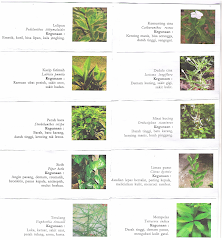
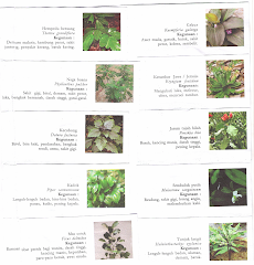


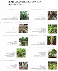.png)