Guidelines for Protected Area Management Categories
IUCN World Commission on Protected Areas
with the assistance of the
World Conservation Monitoring Centre
CANAIMA NATIONAL PARK, Venezuela
National designation Canaima was established as a national park in 1962 under the Forest Law of Lands
and Water, 1943. It presently covers 3,000,000ha of the Gran Sabana and the mid-Río Caroní. Land is
owned by the Venezuelan government, although the traditional occupants, the Pemón, have claimed land
rights.
Legal basis for management Provisions for a national park under the 1983 Organic Law of Territorial
Planning include protection of Canaima as a natural area unaffected by human disturbance, and
encouragement of recreation, educational activities and research. Hunting and collection of wildlife is
forbidden.
In situ management Objectives formulated in the management plan include provisions for indigenous
agricultural production under strict regulation. Tourism is encouraged but restricted to designated areas.
Geography Canaima includes the uplands of the Gran Sabana and the eastern tepuis (table mountains) of
the Roraima Range, as well as the sandstone plateau of Chimantá and Auyán-Tepui and the north-western
Canaima lowlands. A main road from Ciudad Bolívar runs along the eastern border of the park, bisecting its
south-east corner. There are no other metalled roads within the park, the western section being accessible
only by air.
Nature conservation values The Guayana Shield, formed some 600 million years ago, exhibits an
extraordinary geomorphology produced by weathering processes. The Gran Sabana is an undulating plateau
between 800m and 1500m, from which rise the tepuis up to 2000m above the plateau. The tepuis are flattopped
mountains with almost 90? slopes. There are numerous waterfalls, including Angel Falls, the world's
highest with a free fall of 1002m. The high degree of endemism found on the summits of the tepuis has led to
the recognition of Pantepui as a unique biogeographical entity. For example, Pantepui is home to 35–40
endemic bird species, most of which occur within the park.
Cultural and social values The park protects the headwaters of the Caroní River which supplies Guri, the
country's largest hydroelectric power station and source of 60% of the nation's energy. The park is sparsely
inhabited, mostly by indigenous people and with less than one person per km?. The forests and savannas have
been occupied for centuries by various groups of Amerindians of the Carib family, collectively known as the
Pemón. Many Pemón maintain traditional lifestyles of swidden agriculture, hunting and gathering. They also
trade tools and artifacts. The park currently receives 100,000 visitors per year.
Reasons for classification as II (National Park) Canaima is an exceptionally beautiful natural landscape,
centred on the Guayana Shield, with its unique and fragile geological, biological and cultural features. As one
of the largest national parks in the Neotropics, it is of sufficient size to conserve ecosystems representative of
the Guayana Shield. It is protected, with legal provisions for research, education and recreation, and rights
granted to the indigenous inhabitants.
KAKADU NATIONAL PARK, Australia
National designation Kakadu was established as a national park in three successive stages from 1979 to
1987, with additions in 1989 and 1991, under the National Parks and Wildlife Conservation Act, 1975.
Approximately one-third of the 2,027,710ha is owned by two Aboriginal Land Trusts, although this is leased to
the Australian Nature Conservation Agency for management as a national park. The rest of the park is
owned by the Federal Government.
Legal basis of management The National Parks and Wildlife Conservation Act provides the primary
legal basis for the protection of natural regions, scenery, flora and fauna for scientific, educational and
recreational purposes, although six other legal instruments are relevant to the park.
In situ management Management is overseen by the Australian Nature Conservation Agency and a Board
of Management with an Aboriginal majority. Consultation with the traditional Aboriginal landowners is
extensive. The general management principles are: to allow the Aboriginal landowners to exercise their rights;
to conserve natural and cultural features; to provide for public appreciation without conflicting with the first
two principles; and to promote the park's values to visitors.
Geography Situated between Wildman and East Alligator rivers in the Northern Territory, Kakadu lies
200km east of Darwin. Conditions range from a wet coastal belt facing the Van Diemen Gulf to a drier
interior.
Nature conservation values Kakadu supports a significant fraction of Australia's flora and fauna, with
more than 51 mammal, 275 bird, 75 reptile, 25 frog and over 55 freshwater and estuarine fish species. This
extremely rich fauna includes 33% of Australia's bird species and 25% of its fish species. The wetlands are
an important wintering habitat for non-breeding Asiatic waders. Over 1000 species of plants, representing 13
communities, have been recorded in preliminary surveys.
Cultural and social values The area is outstanding in the antiquity and quality of its 1000 archaeological
sites, some dating back 25,000 years. Approximately 3000 rock art sites have been located so far, but it is
estimated that there are double this number of such sites in the park. Excavated sites have revealed evidence
of the earliest human settlement in Australia and the world's oldest evidence for the technology of edgeground
axes; occupation appears to date back some 69,000 years. Many sites continue to hold religious
significance for the Aboriginal people. Visitors may exceed 40,000 in peak months.
Reasons for classification as II (National park) Kakadu's spectacular landscape reflects Australia's
historic interactions with New Guinea and Asia, resulting in an exceptionally diverse flora and fauna. The
area is relatively pristine and includes a complete river system and representative landforms, habitats and
associated species, all of which are protected for scientific, educational and recreational purposes. Kakadu is
an important Aboriginal site; provision is made for Aboriginal landowners to continue to exercise their rights.
RAS MOHAMMED NATIONAL PARK, Egypt
National designation Ras Mohammed was notified as a national marine park under Decree No. 1067 in
1983. Subsequently, in 1989, it was classified as a national park and extended to 61,500ha to encompass Tiran
Island, becoming the largest marine park in the region.
Legal basis of management The site is protected under Presidential Law concerning Natural
Protectorates No. 102, 1983 and Decree No. 1067, 1983. Hunting and fishing are prohibited, as is the
removal of any material from the park, or the construction of buildings or roads.
In situ management has increased in intensity and effectiveness since 1988, based on a series of
management plans. Parts of the park are closed to the public, while areas accessible by road or close to boat
moorings are designated for intensive visitor use. Following considerable initial investments, the park is now
becoming self-financing through a system of entrance fees. There are a number of full-time, highly qualified
rangers, equipped with vehicles and boats. Camping is restricted to one small site.
Geography Ras Mohammed lies at the southernmost tip of the Sinai Peninsula. The terrestrial area is
dominated by raised fossil reefs ranging in age from 20 million to 75,000 years. Offshore are the shallow
waters (95m) of the Gulf of Suez to the west and the 1800m deep Gulf of Aqaba to the north-east. Fringing
coral reefs encircle most of the site, and in a number of places the reef front is vertical or overhangs for at
least 100m. Tiran Island is dominated by arid mountains, with small areas of salt marsh on the coastline.
Fringe reefs again dominate the coastline, with four large patch reefs in the Tiran Straits. Tides and strong
currents occur in the 70–1000m wide channels between the reefs and islands.
Nature conservation values Ras Mohammed is a rich and vulnerable marine environment, representing
one of the few protected coral reefs and mangrove forests in the region. An interesting and unusual feature is
the relationship between pelagic fish communities and typical northern Red Sea coral reef communities in the
deep offshore waters. Tiran and it neighbouring islands possess the world's second largest colony of osprey.
Cultural and social values For centuries the Bedouins have used the area for fishing although few, if any,
still fish within the confines of the park. The park is uninhabited and now being developed for tourism,
particularly diving activities. Tens of thousands of tourists visit the park annually from nearby towns, most of
whom snorkel or dive to see the coral reefs.
Reasons for classification as II (National Park) Ras Mohammed is an important coastal site,
incorporating large areas of diverse fringing coral reefs typical of the northern Red Sea. It also features one
of the most northerly mangrove communities in the western Indo-Pacific. Large and uninhabited, the park is
legally protected and provides for recreation.
TONGARIRO NATIONAL PARK, New Zealand
National designation The summits of Tongariro, Ngauruhoe and Ruapehu were constituted as New
Zealand's first national park in 1894, the central volcano area having previously been gifted to the government
in 1887. The Tongariro National Park Act, 1922 provides for the establishment of the park, which currently
covers 79,596ha of government-owned land.
Legal basis of management Under the National Parks Act, 1980 Tongariro is to be preserved in as
natural a state as possible, but with provision for public access.
In situ management The principal management goals are: to preserve the natural scenery and resources; to
promote an appreciation of nature and cultural and historic values; and to provide for recreation. The park is
zoned into natural environment, two wilderness zones, three service areas and some 18 sites of unique
biological or geological interest. Ski-field development has been restricted by zoning. Maori interests are
represented by a permanent seat on the Tongariro/Taupo National Parks & Reserves Board. Native flora
have been reduced or eliminated by exotic herbivores such as red deer and possum. Invasive lodgepole pine
threatened to convert native plant communities into forest but control measures have been taken.
Geography Tongariro occupies the central volcanic plateau of North Island in the Tongariro and Wanganui
regions. The park boundary encircles the Ruapehu, Ngauruhoe and Tongariro mountain massif at an altitude
of 500-1550m. An outlier, 3km north of the main park area and separated from it by Lake Rotoaira, includes
Lake Rotopounamu, Mount Pihanga and Mount Kakaramea.
Nature conservation values The crater lake on Ruapehu is unique due to its high frequency of eruption
and glacial setting. It is an excellent example of the interaction of magma and lake water. The park also
protects deposits from the Taupo eruption 1800 years ago, the most powerful volcanic eruption ever known.
Habitats are diverse, ranging from remnants of rain forest to nearly barren icefields. Podocarp-broadleaf rain
forest, beech forest, scrub and tussock are the predominant communities. The vertebrate fauna is restricted to
mainly birds, some threatened. Native mammals are represented by two bat species.
Cultural and social values The area has been occupied by Maoris since they first arrived from Polynesia.
Ethnic mythology identifies the mountains in the park with 'tupuna' or god-like ancestors. Until the land was
given to the nation in 1887, the area was occupied by the Tu Wharetoa. European attempts to introduce sheep
farming ceased by the 1920s. Recreation is important to the local economy.
Reasons for classification as II (National Park) Tongariro is one of the most spectacular volcanic sites in
the South-West Pacific, with the most frequently active composite volcanoes in the world. The park is
protected to preserve its natural scenery and resources, and to provide for recreation.
WATERTON LAKES NATIONAL PARK, Canada
National designation Waterton Lakes was established as a national park in 1911. It is protected under the
National Parks Act, 1930. Land (totalling 50,000ha) is federally owned and under the jurisdiction of Parks
Canada, apart from 1648ha of timber reserve managed by the Blood Indian Band. In 1932, Waterton Lakes
was combined with Glacier National Park, Montana to become the world's first 'International Peace Park'.
Legal basis of management Under the National Parks Act, Waterton Lakes protects significant biological
and archaeological features, while encouraging tourism, local employment opportunities, and scientific
research. Industrial activities are prohibited.
In situ management The park is zoned2 in accordance with the 1978 management plan. Class I zones
comprise the most unique sites, afforded the highest degree of protection. Class II and III zones provide for
the preservation of wilderness and natural environments, respectively. Class IV and V zones are reserved for
recreation and visitor service centres, respectively. Grazing of livestock, logging and commercial fishing are
not allowed in the park.
Geography The park lies on the eastern margin of the Rocky Mountains, Clark and Border ranges, in the
south-western corner of Alberta Province. An obvious feature of the park is the sudden transition from prairie
to mountain landscape: a contrast which is emphasised by the virtual absence of intervening foothills. The
dominant landforms are of glacial origin.
Nature conservation values Waterton Lakes represents a species-rich locale, lying at the intersection of
several important floristic regions. Some 870 species of vascular plants, 182 bryophytes and 218 lichens have
been recorded. The small area of grasslands is one of only a few good examples protected in the Canadian
national parks system. Waterton Lakes is noted for its abundance of wildlife, and features seasonal migrations
of large ungulates.
Cultural and social values Waterton Lakes is one of the most significant archaeological areas in Alberta,
with over 200 sites identified. A heavily-used resort town lies within the park. In 1986, more than 500,000
people visited the park.
Reasons for classification as II (National Park) Together with the contiguous Glacier National Park in
Montana, U.S.A., Waterton Lakes protects an important ecological unit while providing for tourism.
2These zones (Class I-V) bear no relation to the IUCN Protected Area Management Categories described in these
guidelines.
KRUGER NATIONAL PARK, South Africa
Kruger is a vast area of arid and semi-arid habitat types, covering 1,948,528ha. Under the National Parks
Act No. 57, 1976, the natural environment of the park is protected from disturbance. The park supports an
active research programme, with excellent facilities, and provides for recreation on a large scale. The
management plan provides for conservation, education, and recreation services within zoned areas. To
minimise threats from outside the park, fences are maintained along the boundary.
SAGARMATHA NATIONAL PARK, Nepal
Sagarmatha is a large (114,800ha), ecologically discrete unit of geological, biological and cultural importance.
Geologically one of the most interesting regions in the world, with outstanding scenic and wilderness qualities,
it includes the world's highest peak, Mt Everest. Under the National Parks and Wildlife
Conservation Act, 1973, Sagarmatha is designated for conservation, management and utilisation of its plants,
animals and landscape. Prohibited activities include damage to plants or animals, residence and livestock
grazing. Management is directed towards watershed protection to safeguard the wildlife and the interests of
the resident Sherpas, as well as those communities living further downstream. The park is zoned into
undisturbed cores and other areas, which provide for tourism and sustainable resource use by the indigenous
Sherpas. The 63 Sherpa enclaves within the park are exempt from park regulations. Agro-pastoralism is still
practised, but goats have been removed from the park to minimise overgrazing. Tourism is now an integral
part of the local economy. A Park Advisory Committee provides a mechanism for residents to participate in
the park's management.
TATRANSKY NATIONAL PARK, Slovakia
The park lies in the Tatra Mountains, relatively young (late-Tertiary) and part of the Carpathian Range. It
features a mix of species, some endemic, from northern and southern Europe. Covering 74,111ha and
established as a national park under the Slovak National Council Act, 1948. Tatransky is protected under
the State Nature Conservancy Act, Law 1/SNR 1955 as an area valued for its natural resources and
recreational importance, and little influenced by human activities. The legislation provides for zoning, with
recreational development restricted to a controlled area. Hunting is prohibited. Over 50% of the land is owned
by the government, the rest is under municipal, private and church ownership. About 4,000 people reside
within three villages inside the park. Part of the core area was traditionally used for pastoralism. The main
pressure today is from the four million annual visitors. Park management has developed strong research and
public education programmes.
YELLOWSTONE NATIONAL PARK, United States of America
Lying in the Rocky Mountains, Yellowstone is a volcanic plateau and contains the world's largest and most
spectacular collection of 3000 thermal features. Established by an act of Congress in 1872 as the world's first
national park, it presently covers an area of 898,349ha, most of which is pristine wilderness. Under the
National Park Service Act, 1916, Yellowstone's outstanding scenery and natural resources are conserved,
while providing for public access and enjoyment. The park is divided into natural, historic and development
zones. A fire management plan was adopted in 1976, policy being to allow natural fires to burn throughout
70% of the park. Some 3 million people visit Yellowstone each year. The 300 people involved in scientific
research and park management reside within the park.
Usia 40

Mudah mudahan diluaskan rezeki anugerah Allah
usia 40 tahun

UPM

Kuatan Pahe Darul Makmur

pemakaian serban semsa menunaikan solat_InsyaAllah ada sawaaban anugerah Allah

Rempuh halangan

Abah_menyokong kuat oengajian Ijazah UPM

usia 39 tahun

usia 23 tahun_UPM

An_Namiru

Ijazah Pengurusan Hutan UPM

General Lumber_Nik Mahmud Nik Hasan

Chengal

Tauliah

Semasa tugas dgn general lumber

PALAPES UPM

UPM

Rumah yang lawa

semasa bermukim di Kuatan Pahe Darul Makmur
Ijazah

air terjun

Borneo land

GREEN PEACE

Kelang

Ahlul Bayti_ Sayid Alawi Al Maliki

Asadu_ Tenang serta Berani

atTiflatul Falasthiniin

Sayid Muhammad Ahlul Bayt keturunan Rasulullah

AnNamiru_SAFARI_Kembara

AnNamiru_resting

Hamas

sabaha anNamiru fil nahri

Namir sedang membersih

Tok Guru Mualimul_Mursyid

An_Namiru
.jpg)
Namir_istirehat
.jpg)
SaaRa AnNamiru fil_Midan
.jpg)
Renungan Sang Harimau_Sabaha AnNamiru
.jpg)
Syaraba AnNamiru Ma_A
.jpg)
AnNamiru_Riadhah
.jpg)
AnNamiru_Riadhah
.jpg)
AnNimru ma_A waladuha

Namir fil_Ghabi (sebut Robi...

Namir

Kijang_ makanan berkhasiat...

Seladang fil_Ghabi (sebut Robi...

Tangkas_Perkasa_ berkhasiat
AnNamiru fil_Ghabi (sebut Robi)

Tangkas_Berani
AdDubbu_Beruang di hutan

Amu Syahidan Wa La Tuba lil_A'duwwi

AsSyahid

Namir

Tangkas
najwa dan irah

sungai

najwa

najwa

Kaabatul musyarrafah

unta

Jabal Rahmah

masjid nabawi

masjid quba

dr.eg

najwa dan hadhirah

along[macho]
![along[macho]](https://blogger.googleusercontent.com/img/b/R29vZ2xl/AVvXsEjuMi7D33CmR0_KXrCW2XigfLcUuQurcvtqOS139ncCwEzCyB-jUopk7QK7anADIenJEm2S0N6gAY1ubnACYXewgiAsI3rBjnLTawM39alLL-rEopOoVqn0w5WpLhPJH3hrXNtchEhgtyaI/s240/P7150023.JPG)
harissa dan hadhirah

adik beradik
Tongkat Ali

Tongkat Ali
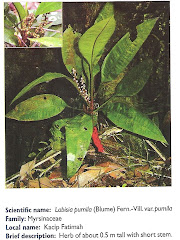
herba kacip Fatimah
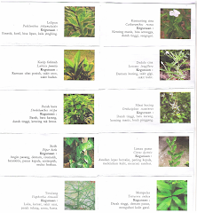
herba Kacip Fatimah
hempedu beruang
hempedu beruang
hempedu bumi

hempedu bumi
herba misai kucing

herba misai kucing
herba tongkat Ali
.png)
Tongkat Ali
Ulama'

Ulama'
kapal terbang milik kerajaan negara ini yang dipakai pemimpin negara

kapal terbang
Adakah Insan ini Syahid

Syahid
Tok Ayah Haji Ismail

Saifuddin bersama Zakaria

Dinner....
Sukacita Kedatangan Tetamu

Kalimah Yang Baik

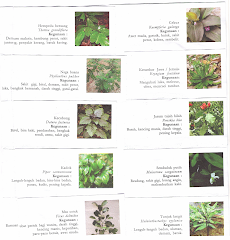
Ubi Jaga
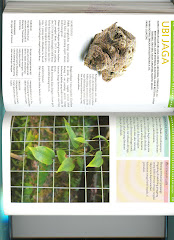
Ubi Jaga
Burung Lang Rajawali

Chinese Sparrowhawk
Kelicap Mayang Kelapa
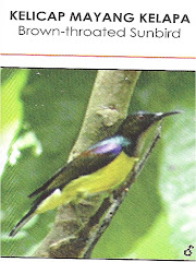
Brown-Throated Sunbird
Kopiah

Pokok Damar Minyak

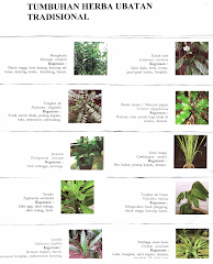
Kacip Fatimah
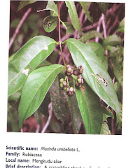
Mengkudu Akar