Guidelines for Protected Area Management Categories
TAMSHIYACU-TAHUAYO COMMUNAL RESERVE, Peru
National designation Tamshiyacu-Tahuayo was notified as a 322,500ha communal reserve in 1990 under the Regulation of the Conservation of Flora and Wildlife, 1977 relating to the Forest and Wildlife Law, 1975.
Legal basis for management The Forest and Wildlife Law and its subsequent Regulation of the Conservation of Flora and Wildlife provide for the conservation and exploitation of wild resources (usually fauna) within communal reserves for the benefit of local communities. Beneficiaries are responsible for the management of the reserve according to the regulations issued by the local forest administration. No exploitation, other than that carried out for the benefit of local communities, is allowed. Permitted activities typically include sustainable hunting and harvesting of non-timber forest products, such as seeds, fruits, bark, latex, leaves and medicinal plants.
In situ management The reserve is zoned into a totally protected core and a surrounding resource-use area, in which subsistence agriculture and sustainable exploitation of wild resources are practised. Local inhabitants hunt deer, tapir and peccary as important sources of protein. Palm fruits are harvested without damaging the parent trees by tree climbing and other appropriate techniques. Agroforestry is also practised using small, multi-species plots. Fishing takes place in the major rivers and ox-bow lakes, but it is regulated by the Ribereño communities: the use of nets and lances is prohibited during low water, and commercial fisheries are banned.
Geography The reserve lies in north-east Peru between the Tamshiyacu, Tahuayo and Yavari Miri rivers in an area of non-flooded terra firme forest.
Nature conservation values Tamshiyacu-Tahuayo supports a rich flora and fauna, including 13 primate species, two of which are not found within any other protected area. Its terra firme forest complements the flooded forest of the nearby Pacaya-Samiria National Reserve.
Cultural and social values There are no residents within the reserve, but some 4,300 people live on its borders, and a further 2,000 people live close enough to benefit from the exploitation of its resources. The inhabitants are semi-indigenous, non-tribal people known as ribereños.
Reasons for classification as VI (Managed Resource Protected Area) Tamshiyacu-Tahuayo is a large, predominantly natural forest that is communally managed to conserve its biological diversity, while providing its semi-indigenous inhabitants with a range of natural products for local use or consumption. Sustainable use of wild resources is restricted to an area of subsistence use that surrounds a strictly protected core.
TONDA WILDLIFE MANAGEMENT AREA, Papua New Guinea
National designation Tonda was declared a wildlife management area in 1975 under the Fauna (Protection and Control) Act, 1966. The entire 590,000ha of land is held under customary tenure.
Legal basis of management Although concerned primarily with the protection of threatened species, the Fauna (Protection and Control) Act provides for the establishment of wildlife management areas, thereby involving customary land owners in the control of wildlife exploitation.
In situ management Under the enabling legislation a Wildlife Management Committee has been established to advise on the provision of rules for the area. Gazetted in 1976, the rules permit customary landowners to hunt freely. Tourists are charged a nominal entry fee and may hunt only deer, duck and two species of barramundi in limited quantities. According to the rules, hunting is prohibited in the region between the Bensbach and Morehead rivers. Other restrictions include the use of vehicles or boats for hunting.
Geography Tonda lies in southern Papua New Guinea on the southern margin of the Oriomo Plain, a relict alluvial floodplain rising to 45m at Morehead Ridge on the northern boundary. Three major river systems traverse the area; impeded drainage causes widespread seasonal flooding.
Nature conservation values The vegetation is similar in physiognomy and species composition to that of northern Australia, in contrast to most of lowland New Guinea. This reflects the strongly seasonal climate and the geological history of former land connections with the Australian continent. The presence of a relict Australian flora and fauna, mixed with species characteristic of or endemic to New Guinea, is important for conservation.
Cultural and social values There are about 1,200 inhabitants distributed among 16 villages. Ten of these villages occupy lands lying completely within the management area and six occupy lands within and beyond its boundaries. The population is mobile and abandoned villages are evident. Hunting, fishing and egg-collecting play an important part in subsistence and cash economies. Shifting cultivation occurs in forest areas, operating on a fallow period of 15-30 years.
Reasons for classification as VI (Managed Resource Protected Area) Tonda was established as a wildlife management area at the request of the customary land-owners for the conservation and controlled utilisation of wildlife and other natural resources. Human population density is very low and much of the area remains wild and untouched.
BUSTARD FISH HABITAT RESERVE, Australia
Declared in 1983 under the Queensland Fisheries Act 1976, the 4550ha reserve protects fish habitats below the higher high water spring tide level. It comprises the least disturbed marine environment in the locality, and supports an unusually high diversity of fish species. Management is the responsibility of the Queensland Department of Primary Industries. The principal management objective is to protect the habitat, while providing for the continued productivity of fisheries. Prohibited activities include damage to the habitat, removal or disturbance to fish and other taxa except by approved methods, and dumping or dredging. However, fishing by approved methods, access, and boating are permitted.
KIUNGA MARINE NATIONAL RESERVE, Kenya
Kiunga Marine National Reserve protects 25,000ha of relatively pristine tropical coastal habitats, managed sustainably for the benefit of the local community. It comprises a narrow strip of mainland, about fifty small offshore islands and the surrounding waters. The offshore islands support large nesting colonies of seabirds. There has been relatively little human interference in the area, other than limited exploitation of local wildlife. As a marine national reserve designated under the Wildlife Conservation and Management Act, 1976, Kiunga is managed for the preservation and sustainable use of its natural resources. Artisanal fishing represents the main local use of natural resources. Tourism and non-destructive activities, such as swimming and sailing, are permitted. Fishing by specified traditional means is allowed, but not by use of poison, spearguns or dynamite. Collection of shells and corals is also prohibited. The passage and anchorage of boats, diving, and access by non-locals are controlled by permits.
Usia 40

Mudah mudahan diluaskan rezeki anugerah Allah
usia 40 tahun

UPM

Kuatan Pahe Darul Makmur

pemakaian serban semsa menunaikan solat_InsyaAllah ada sawaaban anugerah Allah

Rempuh halangan

Abah_menyokong kuat oengajian Ijazah UPM

usia 39 tahun

usia 23 tahun_UPM

An_Namiru

Ijazah Pengurusan Hutan UPM

General Lumber_Nik Mahmud Nik Hasan

Chengal

Tauliah

Semasa tugas dgn general lumber

PALAPES UPM

UPM

Rumah yang lawa

semasa bermukim di Kuatan Pahe Darul Makmur
Ijazah

air terjun

Borneo land

GREEN PEACE

Kelang

Ahlul Bayti_ Sayid Alawi Al Maliki

Asadu_ Tenang serta Berani

atTiflatul Falasthiniin

Sayid Muhammad Ahlul Bayt keturunan Rasulullah

AnNamiru_SAFARI_Kembara

AnNamiru_resting

Hamas

sabaha anNamiru fil nahri

Namir sedang membersih

Tok Guru Mualimul_Mursyid

An_Namiru
.jpg)
Namir_istirehat
.jpg)
SaaRa AnNamiru fil_Midan
.jpg)
Renungan Sang Harimau_Sabaha AnNamiru
.jpg)
Syaraba AnNamiru Ma_A
.jpg)
AnNamiru_Riadhah
.jpg)
AnNamiru_Riadhah
.jpg)
AnNimru ma_A waladuha

Namir fil_Ghabi (sebut Robi...

Namir

Kijang_ makanan berkhasiat...

Seladang fil_Ghabi (sebut Robi...

Tangkas_Perkasa_ berkhasiat
AnNamiru fil_Ghabi (sebut Robi)

Tangkas_Berani
AdDubbu_Beruang di hutan

Amu Syahidan Wa La Tuba lil_A'duwwi

AsSyahid

Namir

Tangkas
najwa dan irah

sungai

najwa

najwa

Kaabatul musyarrafah

unta

Jabal Rahmah

masjid nabawi

masjid quba

dr.eg

najwa dan hadhirah

along[macho]
![along[macho]](https://blogger.googleusercontent.com/img/b/R29vZ2xl/AVvXsEjuMi7D33CmR0_KXrCW2XigfLcUuQurcvtqOS139ncCwEzCyB-jUopk7QK7anADIenJEm2S0N6gAY1ubnACYXewgiAsI3rBjnLTawM39alLL-rEopOoVqn0w5WpLhPJH3hrXNtchEhgtyaI/s240/P7150023.JPG)
harissa dan hadhirah

adik beradik
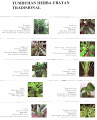
Tongkat Ali

Tongkat Ali
herba kacip Fatimah
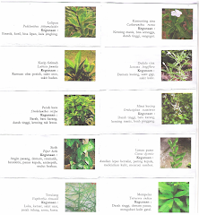
herba Kacip Fatimah
hempedu beruang
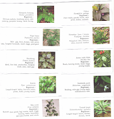
hempedu beruang
hempedu bumi

hempedu bumi
herba misai kucing

herba misai kucing
herba tongkat Ali
.png)
Tongkat Ali
Ulama'

Ulama'
kapal terbang milik kerajaan negara ini yang dipakai pemimpin negara

kapal terbang
Adakah Insan ini Syahid

Syahid
Tok Ayah Haji Ismail

Saifuddin bersama Zakaria

Dinner....
Sukacita Kedatangan Tetamu

Kalimah Yang Baik

Ubi Jaga
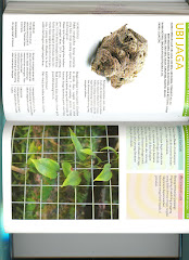
Ubi Jaga
Burung Lang Rajawali

Chinese Sparrowhawk
Kelicap Mayang Kelapa
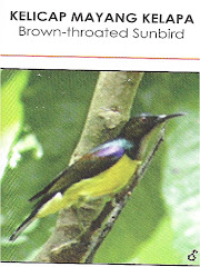
Brown-Throated Sunbird
Kopiah

Pokok Damar Minyak

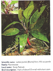
Kacip Fatimah
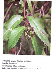
Mengkudu Akar